OSA links are to the Edina site -
go to "browse scanned pages." NSA links are
to the Google Books site.
Additional information about parishes can be found on
the Vision
of Britain site.
The map of Bute below is from the 1923 OS quarter-inch
map, sheet 4. With thanks. The map on the left and of
Arran courtesy of David Rumsey Historical Map Collection.
These are copyright Cartography Associates but have
been made available under a Creative Commons license
for non-commercial use.
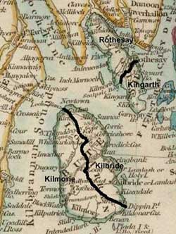
Island of Bute
Kingarth
OSA
Two packet boats each week between Rothesay and Largs
and Greenock. Weekly ferry from Scoulag to the Largs.
NSA
 Lime
supplied to the whole island and also exported from
Kilchattan Bay. Lime
supplied to the whole island and also exported from
Kilchattan Bay.
Rothesay is the market town. Charter of 1703 for Mount
Stuart to become a burgh of regality right to hold
markets, fairs, ports, trades etc not implemented.
No public transport. Nearest post office is Rothesay.
Roads good and suitable for carriages.
Wharfs at Kilchattan Bay and at Scoulag coal landed
there. Communications with the mainland much improved.
Excellent sightlines from Dunagoil.
St Blanes Chapel served the whole island at one time
Rothesay

OSA
Coal is brought in from Glasgow and is expensive. Peat
also used.
NSA
Served as a market where Highlanders and Western Islanders
could trade with Lowlanders. This trade and the town
were badly affected by the founding of Campbelltown
c.1700.
Inchmarnock belonged to the monastery of Saddell in
Kintyre.
Excellent cheese.
Cockles collected at St Ninians Bay and sent to Glasgow.
Seven steam vessels each day to Glasgow these travel
at 11 mph. The first steamer was in 1814.
Thriving market town. Post each day from Greenock and
Glasgow.
The roads are funded by statute labour and the Marquis
of Bute no tolls.
Three poorly attended fairs.
Coal from Glasgow and Ayrshire.
Other references
1. Treasury Accounts
(see reference in Origines Parochiales
Scotiae, Vol 2, pt 1, page
241)
Payment to Robert Spens, quarrier of slates for 13,000
slates and their carriage to the sea and towards Dunbretane
(Dumbarton) for the repairing of the castle £11.10s.
Payments to husbandmen of Bute for mailmartis (cattle)
to be driven from Arnele (Ardneil near Portencross)
to Strivelyne (Stirling) and Edinburgh; also
from Bute to Stirling, and Bute and Arane to the Torwod
(near Stirling)
Cod delivered from Arane to Dunbretane and then to Strivelyne
Fee for operating the ferries between Bute and Cowale
Transport of wine from Stirling to Bute for the King
(OPS)
2. History
of the County of Bute, J Eaton Reid, 1864
No public high roads or bridges built before 1764 when
a statute labour committee was formed. The roads in
Kingarth parish were supervised by Lord Butes factor;
those in Rothesay and up to the ferries of Rue and Kilmichael
by Mr Blair (i.e. Blair's Ferry at Kilmichael and
Rudhbadoch). Roads in the Cummermenoch district
from Rothesay to St Ninians Point were supervised by
Mr Stewart and Mr Campbell (page 120).
1665 Residents of Rothesay required to pay towards paving
of streets.
1700 Blair's Ferry - admonition not to carry passengers
on the Sabbath (The Isle of Bute in Olden Time, James
King Hewison, 1895, vol 2, page 275). Blair's Ferry
was at Kilmichael on the north-west side of the island
and crossed over to Kames. Marie Weir (Ferries in
Scotland, p.148) notes that c.1800 it also crossed
to Skipness in Kintyre.
1765 Mention of a cattle market to be held in Rothesay.
As an incentive there would be a boat at Rothesay and
Scoulag Burn Foot to ferry animals to Largs and upriver,
free of charge.
1769 Bridge over the Water of Rothesay built at a cost
of £41.6.3.
1768 Roads in Rothesay given names viz. Castle St, High
St, Watergate etc.
1772 Roads, bridges and quays in Rothesay improved.
1794 Guns must not be fired on public roads at weddings.
1813 Archibald Stewart of Ascog building a road by Laigh
Barony and the Bay of Ascog to join the high road at
Kerrycroy.
1822 Request to the Post Master General that the mail
which comes from Largs and Kerrycroy in an open sailing
boat be delivered by steamboat from Greenock.
1837 Committee appointed to walk the streets on a Sunday
and mildly admonish such as may be guilty of Sabbath
indecorum.
Mention of ferry at Scoulag in 1680 the ferryman had
to make victuals, drink and lodging available. Ferry
from Dunagoil to Arran set up in 1684 but didnt pay
(page 98)
3. Roads in 1859
There is useful supplementary information for Bute and
Arran here.
 4.
Bute Road Board and Road Trust 4.
Bute Road Board and Road Trust
Board formed
1882; 20 members
Bute & Inchmarnock,
Arran, Cumbrae districts
Initially
the Road Board took over four roads in Bute, 19 in Arran,
none in Cumbrae
| |
Road
Board |
| |
Lord
Bute |
| |
Port
Bannatyne roads |
| |
Replacement
road for the original line that ran through Mt Stuart
policies |
| |
Rothesay burgh roads |
| |
Other road - Rothesay
to Kerrycroy |
The roads in red were those adopted by the Road Board;
those in purple were maintained by Lord Bute and later
were taken over by the Board. The short lengths of road
in Port Bannatyne were also taken over.
Source: Minute Book of Buteshire Road
Trustees and Road Board - C05/2/1/1 Glasgow Archives
(Mitchell Library)
Island of Arran
 Kilbride Kilbride
OSA
There is a mile of cart road from a slate quarry to
the shore at Lochranza.
NSA
Due to the supply of wood on the island being used up
and before the planting of trees, all wood had to be
brought from Ayrshire.
There is no market town on the island. Cattle and produce
are taken to the mainland by steam-boat, particularly
to Ardrossan and Saltcoats. In the summer there is a
steam-boat service to Glasgow.
There are annual fairs in Lamlash and Brodick. At Lamlash
mostly horses are traded; the Brodick fair is busier
and has people attending from the mainland.
The post office is in Saltcoats with regular services
to two sub-offices in this parish.
From Gorton Alister, just south of Lamlash, up to Brodick
there is a Parliamentary road. It was macadamized last
year and has always been kept in good condition. In
1817 this road was extended north as far as Sannox and
at its southern end around the south of the island to
the Blackwater river. This was at the expense of the
Duke of Hamilton, with maintenance being carried out
under the statute labour.
Other roads are one made by the Duke of Hamilton from
Lamlash to Benicarragan in the south of the island and
a Parliamentary road from Brodick to the Blackwater.
All that is needed to complete the road system is to
link Lochranza with Sannox and to build bridges over
Ashdale Burn and the rivers of south and north Sannox.
Peat available locally. Coal is brought in from Ardrossan
and Ayr.
Kilmorie
OSA
Several hundred black cattle are taken to Ayrshire each
year. Barley is taken to Greenock, Saltcoats, Irvine,
Ayr and Campbeltown.
NSA
With no market town or market in the parish, goods are
taken to Ayr, Ardrossan or Campbeltown. A packet-boat
runs from Southend to Ayr and another from Blackwater
to Campbeltown. Proper and safer harbours would be a
great advantage.
A Parliamentary road in excellent condition runs from
Blackwater Foot to Brodick. A good road runs along the
shore between Blackwater Foot and Largybeg; and another
from Benecarigan to Lamlash. The latter road was made
at the expense of the Duke of Hamilton by those who
were in arrears of rent. The other road was made by
the statute labour and both are maintained under this
system. Tenants are required to work three days on roads,
mill-dams and water courses and are called out by district
in rotation by an overseer. There are bridges on the
Duke's property except at Blackwater, Machey and Iorsa
on the confines of the land where adjacent to Mrs Westenra's
land - the roads on this land are poor and there are
no bridges.
The nearest post offices are in Brodick and Lamlash,
served by steam packet from Saltcoats.
Horse fairs are held at Lag and Shedog.
Peat is used as fuel though those near the coast may
use coal.
Other references
History
of the County of Bute, J Eaton Reid, 1864, page 140
The parliamentary roads from Gerton M'Alister, just
south of Lamlash to Brodick and from Brodick to Blackwaterfoot
were made in 1811. These were extended in 1817 to Sannox
and around the south of the island to Blackwaterfoot.
There were also roads made through Moniemore Glen and
Glen Scarodale and to Benan. In 1843 the road was extended
from Sannox to Lochranza. There is also a rough road
round the west side of the island from Loch Ranza.
There are regular steamboat services.
Island
of Cumbrae
OSA
At this time the Cumbraes were part of Ayrshire. The
account says that little was done to the roads except
between Millport and the ferry to Largs.
NSA
By the time of the NSA, Cumbrae had been transferred
to Argyleshire. The only regularly constructed road
was that between Millport and the ferry but the use
of this was being overtaken by direct sailings from
Millport.
Top
|

